|
Training Courses
Tours
Online Videos
|
| The Landscape Circles of the Marlborough Downs |
Extract based on the book The Keys to the Temple
| Introduction
This article outlines the background and discover of a large twin-circle landscape pattern on the Marlborough Downs. It is run over several separate pages (see left panel), which includes the discovery, the relationship with other landscape features and finally its geometric link to the Great Pyramid of Egypt.
|
.jpg) |
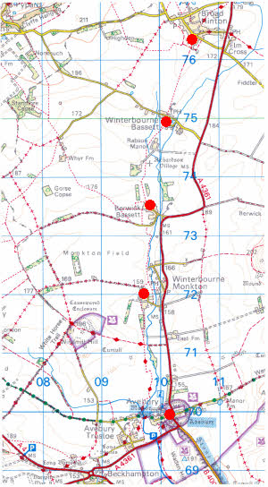 Fig 1. The Church Sites above Avebury
|
The Discovery
In 1975 I made a discovery whilst looking at one of the old Ordnance Survey maps in the Avebury area. With a background in Town Planning I have had a life long interest in maps and this was enhanced when I came across Watkins idea of site alignments that linked together churches and other significant landscape points in straight lines, which Watkins called a "ley line" or simply a "ley".
Leys are an anathema to the archeological establishment because they link sites of vastly different age ranges from the early Neolithic, like long barrows, to Medieval churches spanning a period in excess of three thousand years. To such minds this is highly improbable and in addition statisticians have looked at this concept and concurred that chance alone could account for most "leys". Nevertheless the idea has not quite gone away. Watkins believed, with some good reason, that old churches were built on much older sacred sites and therefore could well have retained a link back into the distant past. My researches into the patterns on the Marlborough Downs lends weight to the principles that Watkins suggested of ancient alignments to significant sites in the landscape.
It was looking for "leys" on the map shown in the panel on the left that I made my discovery. |
A Circle Emerges
I noticed four churches, in the villages of Winterbourne Monkton, Berwick Bassett, Winterbourne Bassett and Broad Hinton, above the famous henge monument of Avebury and looked to see if I could draw any straight lines between them. Watkins had claimed that at least four significant sites were required to create a "ley" and statistically six sites or more is likely to be possibly significant. As much as I tried to link these sites I could not yet the more I looked at them the more connected they seemed to be. And then I realised that perhaps it was not a straight line that linked them but a circle. So I got a large sheet of tracing paper, drew on it a circle to a radius of six miles, a distance which I had discovered seemed to be significant in other "ley" research and placed it on the map.
What emerged left me astounded for not only did the circle pick up all of the above sites but in addition another ten significant places fell on its circumference. This circle is shown below.
|
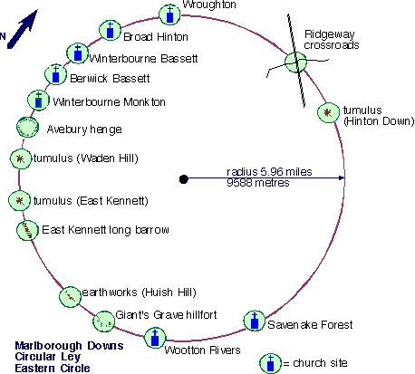
| Fig. 2 The First Marlborough Downs Circle - Discovered in 1975 |
So here was something totally improbable. Instead of a straight line we had a circle, made up of fifteen significant sites. In all of my reaseaches into "leys" I have never come across an alignment of fifteen sites in such a short distance of just under thirty-seven and a half miles. Statistically this is of a very high order of probability.
A Second Circle
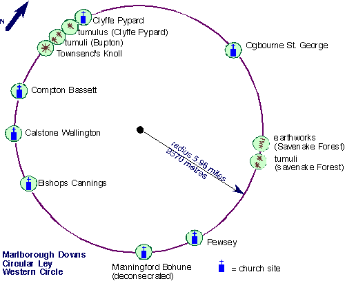
Having discovered the first circle I then looked to see if I could find any more in this area and eventually another emerged with exactly the same circular diameter.
|
| Fig 3. The Western Circle of the Marlborough Downs complex. |
This second circle had slightly fewer points, twelve in all, but still nevertheless a straight alignment with this number of points would still be very significant. This is reinforced by the fact that now two such circles would appear to exist, rather than just one, which, on its own, might have been a statistical quirk.
These circles are interlinked as the diagram below shows:
|
| Fig. 4 The Twin Circle Pattern of the Marlborough Downs (Click image above to enlarge) |
Dimensions of the Circles
| Circle |
Radius |
Circumference |
| Eastern Circle |
9588 metres
5.958 miles |
60.243 km
37.433 miles |
| Western Circle |
9570 metres
5.947 miles
|
60.130 km
37.363 miles |
| Distance between centres |
8124 metres
5.05 miles
|
Bearing between centres 242.1°(degrees)
|
Location Information
Click here for detailed information on the sites of the Marlborough Downs landscape circles giving OS grid references etc.
Statistical Analysis
Click here for a statistical analysis of the Marlborough Downs landscape circles.
 For the next section and further details please click the buttion. For the next section and further details please click the buttion.
Useful Links
follow on articles giving more details of other landscape
patterns.
Twin circles of the
Marlborough Downs explores sacred patterns of Wiltshire
Marlborough Downs
Sites a tour of the sites that make up the twin circle pattern
The Cotswold Circle an
article on a similar sized circle that over-lights the Cotswold area
The Hidden Geometry of
Avebury a look at the hidden geometry of Avebury
Silbury Hill and the Sanctuary an article on
significance of Silbury Hill and the Sanctuary
The Keys to
the Temple information on the book The Keys to the Temple by David Furlong
|
For further information please write to:
David Furlong Myrtles, Como Road, Malvern Worcs WR14 2TH
Tel: +44 (0)1684-569105 or Mobile: + 44 (0)777-978-9047
Email:
David Furlong |
|

David has been working as a healer, therapist and researcher for more than 40 years. He is the author of six books including The Healer Within and Working With Earth Energies
To contact David click here
The definitive book on Working
With Earth Energies.
Click here for more
details.
The book The Keys To The Temple from which the article is taken. Click the image for further details.
Click to enlarge
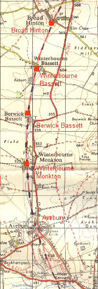
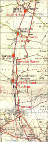
The four church sites of:
Winterbourne Monkton, Berwick Bassett, Winterbourne Bassett and Broad Hinton that led to the discovery of the landscape circles. Click to enlarge
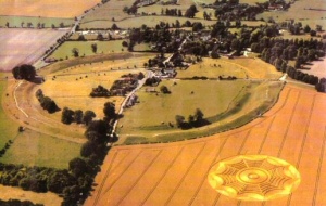
Avebury from the air. One of the key points on the Eastern Circle.
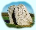
Part of the Avebury Henge
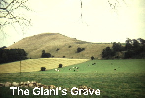
The Giant's Grave: one of the points on the circumference of the Eastern Circle.
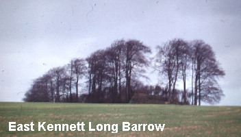
The East Kennett long barrow. A key point on the Eastern Circle.
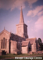
Bishops Cannings Church. One of the key points on the Western Circle
|


.jpg)